We adopted Masha and her sister Bubka in November of 2008, when they were both about three months old. Gwen and I each brought our own cats to the relationship, but these were the first cats we adopted as a couple. They had both been separated from their mother before they were weaned, and as a result, had permanently infantilized behaviors: in Masha’s case, that meant that she liked to suckle on your armpit—mostly on Gwen’s armpit. She had a voracious appetite, and would nose other cats away from their food bowls. She didn’t particularly like sitting on people’s laps, but she had a morning ritual where she would jump up on the rim of our bathroom sink for what I thought of as her “daily adoration.” She would always seek out a beam of sunlight to warm herself in. She always seemed happy.
She spent most of her life living with a chronic health condition: cholangeo-hepatitis, inflammation of the gall bladder and liver. This resulted in a couple of serious health scares before we had it correctly diagnosed and treated. We followed the vet who diagnosed her from one practice to another to another. A couple of years ago, her blood sugar seemed to indicate that she’d also developed diabetes, but we were able to control that with diet. More recently we needed to increase the dose of one of the drugs we gave her. And she was becoming less mobile, so the daily adoration could not take place on the sink.
On Sunday, her normally robust appetite deserted her. She’d had low spells before and bounced back after a few days. This time, Gwen took her to the vet, and the vet just gave Masha a look, and gave Gwen a look. Diagnosis: multiple organ failure. Our vet had previously marveled that Masha seemed unstoppable—she’d have one problem after another and keep going. But in the end, the best we could do for her was not good enough. In the end, it never is.
I had been looking for an ultracycling event that wouldn’t involve a lot of travel, and this popped up. It was billed as 25% gravel, which wasn’t what I’d prefer, but I figured I could make it work. So I signed up. My training leading up to it I felt was OK. Could be better, but I didn’t feel underprepared. I had put 35-mm tires on my bike—1 mm larger than the frame is supposed to accept—so that was as much as I could do to make it gravel-ready. I played around with a couple of bag configurations. I was packing pretty lightly, but wound up using my Tailfin rackbag, which was overkill for the load I put in it. Plus a toptube bag for snacks, and a small frame bag for tools and gadgets.
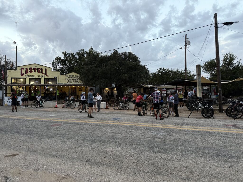
The start/end point is the town of Castell, population 13, midway between Llano and Mason. I had ridden some of the roads around there in the distant past.
Come race day, most of us arrived in Castell the night before. I missed the pre-race meeting, but I don’t think I missed anything important. Eventually I found out where everyone was camping (it wasn’t immediately obvious), and I laid out my air mattress under the stars. It was a clear night and being way out in the country, I could see all of them. I didn’t sleep well due to jitters, something other people mentioned too. In hindsight, I could have rented a hotel room about 20 miles away and slept (or not) in a more comfortable bed.
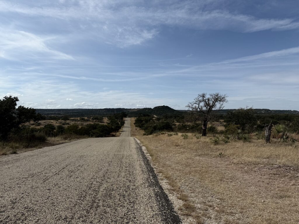
There were four events being run simultaneously: the 500-mile race (mine), a 300-miler, a 173-miler, and an 88-miler. At the start, they had us line up in that order. Only 16 of us in the 500-miler, I think (and only one woman). There was a two-mile neutralized start rollout. After that, at the head of the front pack, there were three people setting a strong pace—no one wanted to get ahead of them, but no one wanted to fall off the back of the train, either. Events like this are supposed to be no drafting, but I decided to enjoy the ride while it lasted. I knew if would break apart before long, and at the first gravel sector, about 20 miles in, it did. This and the next gravel sector both had sand traps that forced everyone off their bikes. At one point I tried walking in the grass along the edge, but that was filled with sticker burrs, which got all over my socks. I carry a tiny plier-type multitool, and it came in handy for removing them.
Even though the pack had broken up, inevitably there are people who ride at about the same speed, so you keep seeing some of the same faces on the route.
There were no resupply points on the route for the first 110 miles, so the organizers let us send bags ahead to a drop site around mile 60, and I took advantage of this. Everyone treated it like a lunch break, and I got to chat with a few of the other riders.
The road
I had been maintaining a pace I was happy with to this point, but starting to get leg cramps. It wasn’t terribly hot, my hydration was OK, I took a salt cap just in case. Didn’t help. In hindsight, I think it might be because of the climbing. The route is covered with short, steep hills that keep coming at you, and I think it was getting to me. Some other riders were complaining about leg cramps too. I read something recently about how different bike positions favor your quads vs your glutes, and I must be in a quad-oriented position, because my quads were killing me, but my glutes seem to have been underused.
Just before reaching Luckenbach at mile 110, I could feel a bad cramp coming on—I saw a slight rise up ahead and thought “if you try to pedal up that, you’ll cramp hard.” So I stopped, and the moment I got both feet on the ground, both legs locked up so hard I couldn’t bend my knees at all. I’ve never had leg cramps like that. I couldn’t even get off the bike. Eventually I did manage to get off the bike and just sat in the grass by the road for a while. Got back on and rode the very short distance to Luckenbach, where a few other riders were already taking a break. So I did too. We talked about the weather, because a big storm was supposed to blow in that night, and people were strategizing where they’d post up. I had checked the weather forecast beforehand and had booked a cabin at the 210-mile point, so I was motivated to get there. I moved my rain jacket out of my saddlebag and into my jersey pocket so I’d be able to get at it at a moment’s notice.
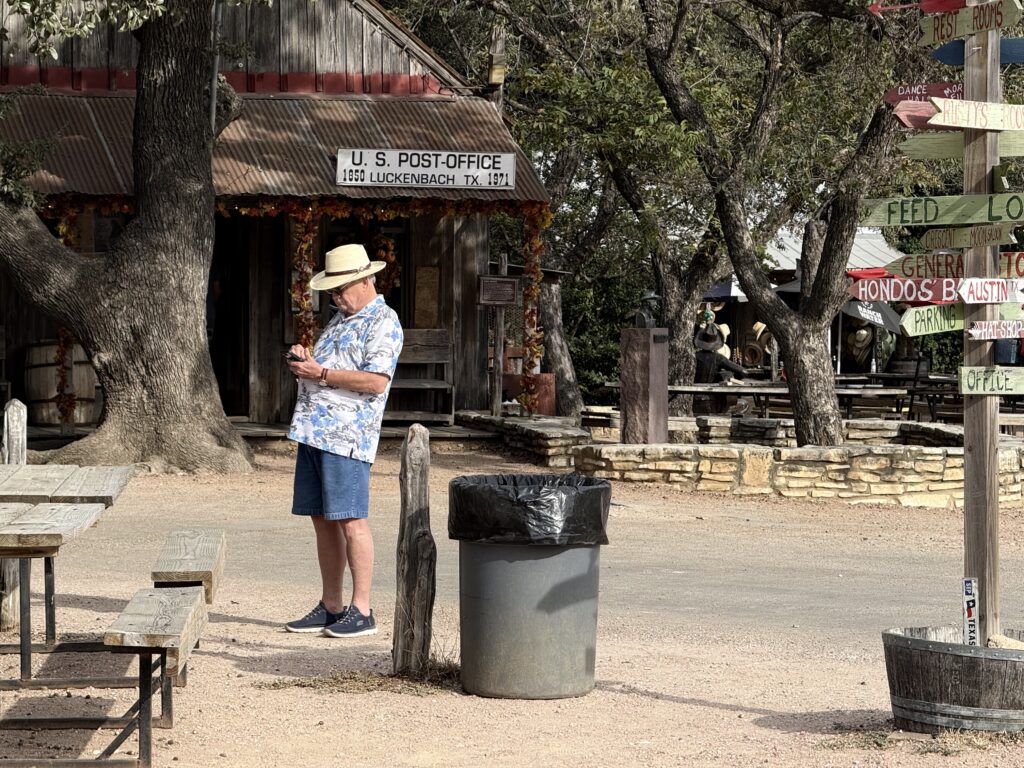
I’d never been to Luckenbach before, and I didn’t realize that it’s nothing but a tourist trap. There’s a bar, a stage, a couple of souvenir shops, and a burger stand. That’s it. No one lives there.
I feel like this photo sums up Luckenbach: an old guy in his standard-issue tourist uniform standing in front of the purely decorative post office
I rode on to Comfort, where I stopped and had some real food. When I rolled out from Comfort, it was getting dark, the weather had cooled off a bit, and I was feeling stronger. My leg cramps stopped. But my poor sleep the night before was catching up with me.
Comfort is where the route for the 300-mile event diverged from the 500-mile event, so suddenly I had a lot less company on the road. Riding these utterly desolate roads in the dark was messing with my brain a little bit, so I put on some music. I hadn’t been listening to music to preserve the battery life in my headset, but at this point it felt like a worthwhile tradeoff.
At mile 170, I hit another gravel sector. Riding gravel in the dark, on a road bike, without experience riding gravel, is not a recipe for success, but I took it easy and stayed upright. I could see a massive lightning storm off to the north.
Around mile 180, the wind whipped up and the temperature dropped 20°F in a heartbeat. On went the rain jacket. A minute later the rain was coming down in sheets. A few miles later, I was on gravel again. Riding gravel in the dark, in heavy rain, on a road bike, without experience riding gravel, is also not a recipe for success, but I took it slow and stayed upright.
The rain jacket did a good job of keeping me dry, but it did nothing to keep me warm. And although it was not objectively very cold, I was freezing: when I’m exhausted, my body can’t regulate its temperature. As soon as I was back on a sealed road, I pushed it as hard as I could (which was not very hard at that point) just to generate some body heat. I had a warm jersey in my saddlebag, but it didn’t make any sense to open that bag up until I was under cover. The town of Utopia was about 15 miles away, and I’d find a gas station or some kind of awning there. I just had to make it there.
The lightning storm was now directly on top of me, with lightnight strikes less than a mile away. I felt exposed.
Made it to Utopia, found a business with a covered front porch, and spent a few minutes assessing and questioning my life choices. During this time, the rain abated somewhat, and I got rolling again. Another 14 miles to the cabin where I’d spend the night. I got there at about 2:00 AM. Although I didn’t check the tracker, apparently I was in 3rd place at this point.
The cabin was rudimentary. I had arranged with the owner ahead of time for my late arrival—he had put the room key in a drop box, along with a laminated printout of house rules in ransom-note style that basically told me not to have any fun whatsoever. I had to pay extra to have sheets. Perhaps if I had paid a little more than that, they would have supplied shampoo, and soap that didn’t leave a waxy coating on everything it touched. They advertised that they had wifi, but it only worked—momentarily—if I was standing in exactly the right spot. My cellular signal, weak as it was, was actually better.
I washed my kit, washed my socks, showered, took care of some minor upkeep, and fell asleep hard. I was awake at 6:05 even without an alarm. I would have preferred to sleep later. I packed up and got rolling quickly.
I was riding much, much slower now. Yesterday had obviously take a lot out of me, especially that final “sprint” through the rain. My goal had been to finish in 60 hours, and there was no way that would be possible at this point. I was feeling discouraged.
I had a breakfast of snacks from my toptube bag and discovered that it wasn’t quite waterproof. I really wanted a hot meal, and looking at the map, I wouldn’t find one for another 70 miles or so. Which added to my discouragement.
The rain had stopped, but there was still a lot of water on the roads, and wet roads lead to punctures: road debris adheres better to wet tires, and has more of a chance to penetrate. And this is exactly what happened, over and over again. I have tubeless tire with latex sealant in them, so minor punctures seal up in a few seconds, but I was getting a puncture every few miles, and I think at some point, I just ran out of sealant, because I had one that wouldn’t seal. It is quite likely I should have had more sealant in there to start with, but it was too late to do anything about that.
This happened on RR 337, a notoriously twisty,turny, and hilly road popular with driving enthusiasts, and I had to walk for a while before I got to a spot wide enough for me to set my bike down and work on it. I was carrying a couple of emergency innertubes, and got one mounted quickly. But I realized that if I was going to keep puncturing—and there was no reason to think that I wouldn’t—my race was over. To be honest, given the mood I was in at that point, I felt completely fine about scratching.
The organizer had some volunteers driving rescue vehicles, so I could call for help, but I’d need to ride somewhere with cellular service before I could do that. There was a crossroads with a store about five miles ahead, and I reasoned that it might have a signal and food, so I made that my destination. It did have a signal, it didn’t have much in the way of food I’d want to eat (it had plenty of cheap beer). I managed to get a message through to the organizer, and one of the rescue volunteers, texted me that he’d pick me up.
One thing about this event that I didn’t fully appreciate beforehand was just how remote it was. I’ve ridden on a lot of remote roads in Texas before, but this sustained disconnection from the rest of the world was different. Riding for an hour and maybe seeing one other person. Cellular coverage being the rare exception, not the norm. Resupply points being so infrequent.
Although most serious cyclists use dedicated head units, I’ve used iphone apps for about as long as I’ve had an iphone. I haven’t used all the apps that are out there, but I have used a few.
My own cycling interests lean towards long-distance rides and bikepacking. Nearly all my rides are solo. This informs what I do and don’t prioritize in an app. I currently do not have a power meter, although that will change at some point. I do use a heart-rate monitor.
The way I use all of these apps during a ride is mostly to rely on periodic spoken updates (via a bone-conduction headset) for my stats rather than looking at the screen. This lets me keep the screen dark, which makes a huge difference in battery life. Although I can keep my phone charged on the road as long as it’s not raining, I have ridden through rain that prevented me from charging my phone for 12 hours, and finished the ride with about 25% battery reserves. So these spoken updates are important to me. I set up each of these apps to recite my average speed and average heart rate for the entire ride, and for the past 15-minute split. I use this to judge my pacing. What I have found is that Ride with GPS doesn’t get these stats correct. Most (but not all) of the updates give the same values for the whole ride as for the last split, which is mathematically impossible unless I have perfect consistency (I don’t). Cadence and Cyclemeter seem to get these right. Navigr8 doesn’t give the option of reporting split average heart rate, though it will report split average speed.
The Ride with GPS app requires that you have an account with the service to use it, although they do offer free accounts as well as two tiers of paid memberships. Navigr8 requires you create an account on sign-in. Cyclemeter, Cadence, and Navigr8 all offer paid subscriptions to unlock additional features; I’ve paid for subscriptions to all of them and am evaluating them on that basis without paying attention to what is available at the free tier.
Cyclemeter, RwGPS, and Cadence all offer live tracking so that the folks back home can monitor your progress: the apps generate a link to a check-in page that you can send out. Cyclemeter can also e-mail notifications at regular intervals. Obviously these all depend on having internet connectivity during your ride. If you and the people who tracking you have Apple products, you can just use Find My, so this is mostly useful when sharing your progress with someone who does not.
Cadence and Navigr8 can keep the screen active but dimmed—I think of this as pseudo-locking. This is nice because it means you don’t need to unlock the screen in order to view the dashboard, just tap on it, but it also means that the screen is susceptible to unintended taps, and on Navigr8’s busy screen, that’s potentially a problem.
Battery life
The usual knock against using a smartphone as a bike computer is that the battery life isn’t good enough. I just described how I’ve adapted to using periodic spoken updates instead of keeping the screen on. But what if you want to keep the screen on, and don’t have a dynamo hub to keep the phone charged? What kind of battery life could you get?
I have an iPhone 16 Pro. This model is known to have great battery life in general. It’s about a year old and the battery health is rated at 100%. I set up Cyclemeter to keep the screen on for the duration of my ride, turned on energy savings, turned off wifi, and left the screen brightness at whatever level I normally keep it at (good enough for most conditions, but not direct sunlight). I had two Bluetooth devices connected: a heart-rate monitor, and a bone-conduction headset (playing music for most of the ride). After a ride lasting 2:50, the battery was at 82%. Assuming the burn rate is linear, this works out to about 6.35% per hour, or about 15.75 hours of use. Call it 12 hours to leave something in reserve in case of emergency. That is not as good as a top-tier bike computer, but it is good enough for a lot of situations.
Cyclemeter
Cyclemeter is one of the oldest apps on the App Store, and it shows. It is decidedly old-school in some ways: it relies on e-mail for outbound communication. It has a monolithic database rather than individual route/ride files. It organizes rides based on routes, which makes a certain amount of sense when performance over a known route is the only way you have of judging your fitness progress, but makes less sense in light of newer training metrics. Setting up the dashboard (Cyclemeter calls this the “stopwatch”) pages is really tedious.
It’s not all bad though. The dashboard display is the best of the lot, and is the only one that looks like a native app (it was developed for the iPhone but eventually was released for Android also). There’s good “fit and finish” on everything. Someone using the app for the first time should be able to launch it, tap the Start button, and go for a ride without any further instruction: the basic features are intuitive.
One quirk of this app is that although it can show a map view as a dashboard cell, you can’t pan or zoom that map. Instead, there’s a separate map tab for that. The dashboard can show a course elevation profile, but this is barely readable.
A Cyclemeter dashboard panel
Ride with GPS
RwGPS is better known as a service for designing and sharing routes, but they do offer their own bike-computer app that is closely integrated with the service. RwGPS has staked out a different territory than Strava, and is not so much oriented toward performance cycling as toward touring, long-distance riding, and route-sharing. It does have segments and some of the same social features as Strava, but these don’t seem to be widely used. The app reflects this different focus. It lacks some pretty basic features, like a lap button. The dashboard screens give limited customization: you get 2 pages with 5 fields each, and you can customize what goes in each of those. And those fields are displayed in small type—the focus is on the map. But the app gives very fine-grained control over navigational alerts.
This is the only one of these apps that does not offer a dark mode. This is not just an aesthetic matter: all newish iphones have OLED displays, which means that only the lit-up pixels use electricity. A display that is mostly black will use less power. RwGPS partially makes up for this by being the only one of these to use live updates on the lock screen, a relatively new iOS feature, which lets you check your basic stats without unlocking the screen at all.
As far as I can tell, RwGPS is the only one of these apps that will display a cue sheet.
Like Cyclemeter, it’s intuitive. A first-time user shouldn’t be confused by it. A very high degree of “it just works.”
A RwGPS dashboard panel
Cadence
Cadence is a newer app that’s trying to do it all: it acts as a regular bike computer, it lets you design routes, and lets you design structured workouts. This is ambitious for a one-man shop.
The way you edit the dashboard pages in Cadence is to go into the settings, where you can view a simplified schematic of your grid, and tap on cells to set their contents. Cadence gives you a lot of flexibility in how you populate the grid; it’s the only app that will show three cells in a row, and it maintains a completely separate set of dashboard layouts for landscape orientation. It’s the only one of these apps designed to work in landscape as near as I can tell. It can also show graphs in cells (of heart rate, for example), although this is just a novelty if you’re cramming the graph into a small cell.
One quirk of this app is the companion Apple Watch app: When you go for a ride, the Apple Watch will normally detect that you’re going for a ride, tap you on the wrist, and ask if you want to record the ride using Apple’s own Workout app. If you’re using one of these apps, you probably don’t want to do that. Cadence’s watch app will override the “do you want to record this?” notification, but not the wrist tap, which quickly gets annoying. I haven’t found a way to prevent that, short of turning off reminders from the Workout app entirely. I mentioned this to the developer and he shrugged it off. This is too bad because I like Cadence’s watch app better than any of the others on its own merits.
In theory, Cadence can import externally created routes, but in practice, this feature is not useful: it can only import GPX files, and it seems that a GPX file can either contain a path, or waypoints, but not both (or at least, RwGPS will only export one or the other but not both). It seems that the author is more focused on fleshing out the app’s internal route-design features than working with external services like RwGPS.
This is the only one of these apps that can run structured workouts. As of this writing, it cannot control a smart trainer, but the company’s website says that is planned for a future release. That would add a lot of value to this app.
A Cadence dashboard panel
Navigr8
Everything about Navigr8 is just nerdy and cartoony, starting with the name. The dashboard display is unpolished, with colorful icons, gridlines that are inconsistent and get chopped off by the screen’s rounded corners (not obvious in the screencaps), bad typography (is that…Arial?). The off-track and on-track trumpets sound like they’re from a circus. The map tiles try to cram way too many controls in, and in direct sunlight, they’re barely visible. The overall fit and finish feels poor. Although all these apps let you swipe left and right through dashboard pages (even RwGPS), this is the only one that doesn’t show swipe animations, which is frankly jarring.
Another jarring aspect of this app is that navigation and ride recording are separate operations. Normally one would load a route, tap the start button, ride the route, tap the stop button, and you’re done. With this, you load the route, tap the “navigate” button to navigate it, tap the “record” button to record the ride, then tap the “stop” button to finish the ride, and tape the “on track” (or “off track”) button to stop navigating.
The way you edit the dashboard on this app is by defining the grid in the settings, and then on the dashboard itself selecting each cell to decide what goes into it.
Navigr8 gamely attempts to estimate power based on what data you can give it if you don’t have a power meter, but I don’t believe the numbers it produces are remotely accurate.
It supposedly has something like Garmin’s ClimbPro that pops up an elevation profile when you’re on a big climb, but I did not see this. The elevation-profile cell shows a fixed-distance look-ahead, and can step through a few distance options.
One great feature is the ability to add a waypoint while riding, with a spoken note. The documentation goes into considerable detail on its waypoint features, and how they can be used to trigger certain events, which sounds interesting, but isn’t something I’ve tried.
I eventually got imported routes to work correctly, but it took some experimentation. There are a number of file formats that can be used in conjunction with bike-computer apps. GPX, FIT, TCX, KML. GPX is probably the best known, but least useful for sending turn-by-turn directions. It seems that a GPX file can contain either the route as lines on the map, or directions, but not both. FIT can contain both, and is a binary file format. TCX can contain both, and is an XML format. Navigr8 could import a FIT file, but treated it as the route only, without directions. A TCX file worked correctly, with both the route and directions and a custom POI that I added working correctly.
Getting a TCX file from RwGPS into it is a bit of a trick. The RwGPS app will not export TCX files or share them using the standard share sheet. In order to get the TCX file:
Open the RwGPS website in your iphone’s browser.
Navigate to the route you want, and under the MORE menu select “Export as File.”
Choose the “TCX Course” file type and download it.
Open the Files app. The Files app separates your files between “on my phone” and “iCloud Drive.” Make sure you’re in iCloud Drive.
Open the Downloads folder.
The downloaded TCX file should be at the top of the list. Press and hold on it to bring up a menu of options, and tap Share.
From the resulting list of share targets, select Navigr8. You might need to scroll to the side of the sideways list of target apps and tap “More” to find it.
This is kind of a pain. RwGPS could make it easier if they wanted to.
Navigr8 has a lot of promise, but it needs a lot of work.
A Navigr8 dashboard panel
Feature comparison
Feature
Cyclemeter
RwGPS
Cadence
Navigr8
Dashboard
Custom dashboard pages
🟢
🔴
🟢
🟢
Music control
🟢 Locally stored music only
🔴
🔴
🔴
Weather data
🟢
🔴
🟢
🟢
Elevation profile
🟢
🟢
🟢
🟢
Offline map tiles
🔴
🟢
🟢
🟢 Possible but awkward
Map providers
Apple, Google
Numerous
Apple, Google, Mapbox
Apple, Google
Lap button
🟢
🔴
🟢
🟢
Custom screen lock
🟢
🟢
🟢
🟢
Screen dim
🔴
🔴
🟢
🟢
Integrations
Ride with GPS
🔴
🟢
🔴
🔴
Training Peaks
🔴
🔴
🔴
🔴
Intervals.icu
🔴
🔴
🟢
🟢
Strava
🟢
🟢
🟢
🟢
Apple Health
🟢
🟢
🟢
🟢
Navigation
Turn-by-turn directions
🔴
🟢 Works with RwGPS maps only
🟢 Internally designed routes only
🟢 With some trouble
Live tracking
🟢
🟢
🟢
🔴
Notifications
Live activities on lock screen
🔴
🟢
🔴
🔴
Periodic spoken notifications
🟢
🟢
🟢
🟢
Other
Apple Watch companion app
🟢
🟢
🟢
🟢
Alternative display device
🟢 House-brand dashboard panel
🔴
🟢 ActiveLook AR glasses
🟢 ActiveLook AR glasses
Training Plan manager
🟢
🔴
🟢
🔴
Ghost competitor
🟢
🔴
🔴
🟢
Other thoughts
Most bike-computer apps offer a lot of flexibility in dashboard layout, but not a lot of discipline. It would make more sense to have rows of related items. Like all heart-rate data on one row, all weather day on one row, etc. Grouping like data together should make it possible to show more data more clearly in less space.
They also don’t show a lot of creativity in how data is displayed—for the most part, they’re taking the same “spreadsheet” approach that head units do, when so much more is possible. I’d love to see a histogram of my heart rate with the current zone highlighted, for example. But to take the spreadsheet concept in a different direction, a bike-computer app could give users the option to fill each cell with the result of a formula, given certain data primitives as terms in the formula. To go a step further, I imagine an app where the dashboard is a WebKit view that takes advantage of HTML, CSS, Javascript, and a library like D3 for data visualization. Custom fields could be shared as small chunks of code.
Years ago, when Saab was a company that made cars, they had a feature they called “night panel,” which would black out all the instruments except for the speedometer and anything that required your attention. I imagine something like this for a bike-computer app, where the screen “pseudo-locks” the way Cadence does, and you can specify certain fields that will stay lit up in this state.
If you use Training Peaks or other external services that aren’t well-supported, you probably want to download either HealthFit or RunGap. These both act as “switchyards” for your workout files, and can sync them to and from external services. I’ve tried both and am currently using HealthFit.
Randonneuring is a cycling discipline—is sport the right word?—that’s somewhere between racing and touring. You complete a planned route before a certain cutoff time, but finishing order doesn’t matter. Rando events have a few standardized distances: 200K, 300K, 400K, 600K, and 1000K. There are longer events as well, including the big show for randonneuring, Paris-Brest-Paris at 1200K. Each of these has a standard cutoff time; for a 600K, it’s 40 hours, and that includes whatever sleep and other off-bike activities you need to squeeze in.
Our local chapter posts a series of events every year, and I was interested in completing a 600K, so I signed up. It turns out I was the only person who signed up.
I’ve ridden nearly the same distance over a two-day period in my failed attempt at the TABR in 2023, although the circumstances were different then—I was in better shape, but I was carrying a lot of cargo. There was much more climbing, but Day 1 also had a massive tailwind. So it’s hard to compare the efforts.
I went into this knowing that I was pretty under-trained for this attempt, and would be getting through it on the basis of good pacing and orneriness.
Day 1
Day 1 was a 357-km (222-mile) loop heading northwest > northeast > southeast > southwest. I had probably been on half the roads at some point before. In general, the area west of Austin is hilly and dry; to the east it’s flat and wetter, with a lot of farmland. I generally prefer the former to the latter both in terms of aesthetics and riding quality. Hills are interesting and have knowable end-points. But in the flat farmland to the east, there is nothing to slow down the wind, which just grinds you down. Very few trees for shade.
Around Krause Springs, I noticed that the Hill Country Ride for AIDS was underway, and passed some of the participants. Gwen and I did that ride back in 2005. I noticed this time around a lot of the riders were on ebikes. This is a good place for it, because it is one of the prettiest places in Texas, especially when the wildflowers are in bloom.
I stopped for a sandwich in Marble Falls, about a quarter of the way through. This was the last real food I’d have until I got home. Mostly I was fueling myself with fruit-based energy blocks and the occasional Snickers bar. Appropriate fueling is a problem for me because in a Zone-1/2 ride like this, I can go for a really long way without bonking—I’ve finished 200Ks on no more than a few energy bars. But certainly this ride would put me deep in the red, and bonking would be really ugly.
I had been feeling a little off up to this point—nothing specific I can point to. I was nervous about this ride, and perhaps I was burning off that anxiety. After Marble Falls, I got into the zone better—and zoned out. I turn inward on rides like this, just focusing on what I’m doing, not so much on my surroundings, except for traffic.
Burnet had what seemed like it had once been a grand downtown, but was almost completely vacant now.
Florence was weird—there was a sharp rich/poor divide, only made more apparent by the fact that there’s basically one downtown street where the two sides are forced together. Some guy who was very impressed with his car (and its modified exhaust system) was making passes up and down the main drag rattling the windows.
When I reached Milam County, I was still about 60 miles from home, but I felt like I was on home turf—I know the roads, and I know the area. I had been riding conservatively to that point—and had mostly been riding into headwinds—and at this point, I knew I could turn up the heat a little bit. My knees were bothering me a little bit. Not the kind of trouble you get from bad positioning, just the cumulative effect of a lot of miles. I’d had some brief and minor episodes of hotfoot, but nothing bad (and never in the same place twice). At this point, my ass was really starting to bother me.
I rode the last 30 or so miles in the dark. And for the last 15 or so, my speed dropped off. This was not so much because I was tired (though obviously yes I was). I was losing the mental discipline to keep my speed up; I was on increasingly urban roads with more twists and turns. And I was keeping in mind the advice “don’t ride faster than your guardian angel can fly” (that is, don’t outrun your headlights).
I got home at about 11 PM, showered (I smelled like something a vulture would refuse to eat), ate, plugged in stuff that needed recharging, put some drip-wax on my chain, and crashed.
My ass was hamburger meat and my knees were kind of bothering me.
I slept amazingly well, and woke up before the alarm I had set.
I was a little dilatory getting out the door to begin Day 2, and probably could have saved half an hour there. I had about 8.5 hours of downtime from the time I got home until I left. A lot of people riding a 600K would opt for less sleep than I did.
My ass was still on fire, and my knees were still not great. I knew Day 2 would be a slog.
Day 2
Day 2 was an out-and-back route to the east, so, flat farmlands with no shelter from the wind. And like Day 1, it was all headwind for the first half. I knew that my performance would drop on the second day, but I wasn’t sure how much. It turns out the answer was “a lot.” I use the Ride with GPS app to read my cues and record my ride, and it reads out my stats at 15-minute intervals. Under normal conditions, I’d want to keep my heart rate between 120 and 130. On Day 2, my heart rate for a 15-minute interval didn’t go above 110 until the last hour of the ride. I couldn’t push it harder.
Similarly to the day before, I stopped at around the 60-mile mark for a sandwich, and again, that was the last real food I had until I got home. If fueling is a problem for me, hydrating is probably a bigger problem. I keep reminding myself to drink more, and I keep not drinking as much as I should. I’m sure I started Day 2 dehydrated, and I was really beginning to feel it. I know that when we eat, our digestive tract takes water from our bodies to process the food, and I kept asking myself “am I drinking enough to get any benefit from the food I’m eating?” The answer was probably “No.”
At the start I was taking it easy on my knees, but at around the halfway point, they started to feel a little better. My ass did not start feeling better, but I eventually kind of came to terms with it. I spent as much time as possible on the aerobars because that took some weight off my butt, and rotated my position so a less-sensitive part of my butt was on the saddle. What I realized when I was getting toward the finish of Day 2 was that I had been using my aerobar grips and armrests to slightly cantilever my butt out of the saddle, and the pressure on my forearm was tweaking those muscles and my pinkies and ring fingers, probably due to pressure on the ulnar nerves. Also, with just a few miles to go, I developed intense hotfoot on the balls of both feet, probably again from trying to keep weight off the saddle.
I finished with exactly 90 minutes remaining before the cutoff time.
Day 2 was not fun. I did not much like the area I was riding through, and my pain made it difficult to enjoy the ride regardless.
The bike I was riding is set up for comfort. It’s got a position I can hold all day. It’s got a suspension seatpost and stem (I can barely imagine what condition I’d be in if I’d been riding on a rigid seatpost). My tires could be fatter, but they were at a low enough pressure to absorb some bumps. And I’ve ridden similar distances before without being so badly pulverized. So I’m not sure why I feel so beat up now. I think there are two factors:
My previous long-distance efforts were on better roads.
I haven’t been doing a lot of long-distance riding lately to toughen myself up.
Like I said before, I got through this on orneriness. I wanted to prove to myself that I could do it. If I do it again, I’ll go into it with better preparation.
I have been helping my sisters clear out my parents’ old place, and I’ve been dealing with paper. I’ve got three piles going: recycle, shred, keep. The shred pile—anything with personally identifying information—currently comprises about 14 banker boxes. One of my sisters has been hauling away the recycling pile as we go, so I have not fully appreciated its majesty, but it may be about as big. The keep pile is a box and a half. My parents kept every piece of paper that ever entered their lives; they generated paper whenever they had to add up a column of numbers—and then kept that piece of paper, devoid of context. My mom printed every piece of e-mail that seemed like it might be useful someday. Of course, when you print everything that might be important, you guarantee you’ll never be able to find anything without a very labor-intensive filing system, which she didn’t have. Among the papers that I ran across today: at some point, my mom logged into Apple’s website to set up a support call; this led her to a confirmation screen showing that her call was scheduled, with a session ID. She printed that confirmation screen—the most ephemeral thing in the world.
In her book In the Age of the Smart Machine, Shoshana Zuboff wrote about clerical workers at an insurance company around the time the company switched to computerized records. These workers continued to refer to paper files because the computerized information wasn’t “real” to them. Those people were probably from about the same generation as my parents, which I think explains my parents’ relationship with paper somewhat. I’m the opposite—if I print something, it’s because I need it in paper form temporarily, and the electronic version is the canonical, permanent one.
Some of the old paperwork is interesting to consider from our current perspective.
Here’s my father’s old Rolodex. I’ve pulled all but one of the cards out to put in the shred pile. The Rolodex was so dominant that businesses would print their cards on stock with slots to fit on the Rolodex’ rails, and in the case shown here, sometimes had a little tab to get your attention, shouldering aside all those other cards.
Here’s a “home expense record” from 1966. This is basically a paper spreadsheet from the days before spreadsheets. The monthly-record pages are laid out with useful categories, with spaces for budgets and actuals, and each page is a pocket for storing old receipts. At the back is more pages to summarize the year and plan taxes. It’s all well-considered.
I especially like the category for “Miscellaneous expenses: Tobacco – Cosmetics – Beverages – Liquor
Confections – Etc.”
I found so, so many letters, thoughtfully composed and meticulously typed (often by a secretary). It’s a different form of communication that we have all but lost.
There’s a concept from the world of software development called “technical debt”—basically, that code you write today needs to be maintained in the future, and the jankier your code is today, the harder it will be to maintain in the future.
There’s an analog to this in the tangible world. Call it accretory debt.
I’m helping clear out my parents’ home. My sisters have done the vast majority of the work if for no other reason than proximity, but I’m spending my xmas break catching up a little. My parents accreted a lot of stuff. I wouldn’t call it hoarding, exactly, but it’s not far off. There’s a lot of good stuff as well as a lot of stuff that just…never got dealt with. I found tax returns from 1997. My 2nd grade report card. The last of my mother’s baby teeth. My grandfather’s college diploma. There’s going to be an estate sale to try to sell the good stuff, although there’s so much in it that we tend to devalue everything that’s not obviously valuable, and there’s not enough room to display even the stuff that is obviously valuable. Surveying all the stuff is demoralizing, and we keep finding more.
Some of this stuff has been stored for the last 35+ years in the dank basement of the rambling house my parents moved into when I was in college, where it has rotted and/or been chewed on by mice. Now we need to haul it all up stairs, rent a roll-off, have a scrapper come out, have a shredding service come out, etc. Failing to deal with that stuff in a timely manner has inflicted a debt on the future.
Cycling is expensive. Any activity that requires equipment is going to involve some expense, and cycling’s equipment requirements are fractal in nature. You don’t just get a bike, you get clothing. You don’t just get clothing, you get warm-weather clothing, and foul-weather clothing, and cold-weather clothing. You get tools, and not just tools, but tools you carry on the bike and tools you use at home. And so on.
As with most things, you reach a point of diminishing returns in terms of price:performance as you spend more and more money on bike stuff. Where that point lands is an interesting question. There are some good deals out there.
I am in the USA and writing this mostly for a U.S. audience. I’m a roadie so that’s what I know.
Bikes
There are often closeouts on last year’s model of bike, and there are some ebay vendors that seem to specialize in this: here’s one. They have a top-end 2021 model listed for less than half its original retail price (but still very expensive).
The difference between this year’s model and last is usually trivial or nonexistent. Every few years, manufacturers will roll out new versions of their models, but these are not generally earthshaking changes.
Note that when buying a bike this way, it still needs a fair amount of setup work, some of which might not be obvious. You’ll either need to be a competent bike mechanic or hire one to set it up, which will offset some of the discount. Shipping will also be a chunk of change.
There are a number of direct-to-consumer bike brands now. I haven’t ridden any of these, but they’ve been favorably reviewed.
As of this writing, a Trek Domane SL5 is listing for $3500, compared to $2000 for a Canyon Endurace CF7 or $1800 for a Fezzari Empire Sport (on sale right now). These are all carbon-framed endurance bikes equipped with Shimano 105 (11-speed)—very respectable, especially for a cycling newcomer. There may be differences in “finishing kit”—saddle, handlebars, etc—and tires that change the balance somewhat.
There are benefits to buying a bike from a local bike shop. They normally throw in a tune-up for free, and will often let you substitute parts to make the bike suit you better for cost. And that’s something you should be prepared for: the stem might be the wrong length, the handlebars the wrong width, the saddle might just be wrong. And there is a benefit in having a relationship with a local bike shop. But damn, that’s a big price difference to overcome. You can pay retail for new saddle, stem, and bars and still come out way ahead. As with a remaindered bike, it would probably be a good idea for cycling newcomers to pay a shop to set up their consumer-direct bike, even though those consumer-direct brands do a better job of shipping the bikes in a ready-to-ride condition.
Clothes
Cycling kit can be ludicrously expensive. The brand that seems to be at the top of the heap, Assos, has a jacket they charge $700 for. Most of us aren’t riding at a level where we can benefit from the marginal performance improvements at those high prices. Here’s some recommendations:
The Black Bibs. Basic designs. Three grades of bib shorts: I’ve got the cheapest ($40) and the most expensive ($80). The expensive ones aren’t as nice as my (much more expensive) Castellis, but they’re absolutely good enough for most riding.
Wiggle’s house brand DHB. Wiggle is a UK sporting-goods vendor. They’ve got a few tiers of clothing products that span a wider price range than The Black Bibs. With the post-pandemic bike bust, they’ve been having financial difficulties, and I read that they might be suspending sales outside the UK, but for now, they still seem to sell internationally.
Galibier. A small UK-based brand. I’ve gotten quite a bit of foul-weather gear from them. Good quality, reasonable prices.
NeoPro. Another inexpensive U.S. brand. As far as I can tell, these guys have one tier of product in everything, and their pricing looks to be in the midrange compared to The Black Bibs. I have not bought from them.
I don’t have any recommendations for shoes. I’ve got one pair of Pearl Izumi cleats that fit me fine, and another from the same brand that I can’t get comfortable in (and would like to sell, if you’re interested). Fit is so contingent on the individual.
Accessories
There are a lot of expensive accessory brands and some reasonably priced accessory brands, but I’m not aware of any distinct bargains. Cheap tools are never a bargain in my experience.
I’ve always had good luck with pumps and tools from Lezyne, and tools from Pedro’s—Pedro’s makes the best tire levers.
If you are jumping into cycling, you should budget for some of this stuff: You should carry on your bike a mini pump, a couple of tubes, a set of tire levers, and a multi-tool. And have some place to store all this stuff—in your jersey pockets, a seat bag, etc. At home, you probably want at least a floor pump. A set of hex wrenches and other hand tools is nice but not necessary. Wera makes excellent tools and their Tool Check Plus is a nice compact home toolkit that’s a good value.
My bike has a SONdelux dynamo hub and I recommend it to anyone interested in distance riding, especially when self-sufficiency is important. I also ride with a power bank, and use my iPhone in lieu of a bike computer. A lot of cyclists dismiss using phones rather than dedicated head units, citing battery-life problems. If you use your phone exactly as you would use a head unit, battery life would be a problem, but you can use a phone differently, in a way that gives good battery life: leave the screen dark and rely on periodic spoken status announcements. For the kind of riding I do, this is fine. Both the Ride with GPS app and the Cyclemeter app can do this, possibly others. Even so, in a multi-day self-supported event, you still need to optimize your phone charging.
I have tried a few different mounting systems for my phone, and Quadlock, which makes the mount I am using currently, does offer a mount with a built-in Qi charger. I’ve tried it, it does work, but the mount is huge and charges less efficiently than the charging port. If you use one of these, you will end your ride with less charge than you started with. If you plug into the charging port, you can keep the phone at 100% charge.
You can charge the phone from the dyno via a USB rectifier (I have this, which is part of a kit with a dyno-powered headlight), or you can hook up a power bank in series and charge your phone and other electronics using pass-through charging. I’ve tried two different power banks at this point: the Nitecore and this Anker model. They both have the same capacity: 10k mAh. The Nitecore, attractively, is the smallest and lightest power bank with that capacity, but the Anker has a couple useful features. One is that it has a Qi charger on its body. This could be important if your phone’s charging port gets wet (this has happened to me on a long ride–it can take a long time for that port to dry out once wet): you can’t charge via the port when it’s wet, but with a Qi charger, you can still charge wirelessly. I also found that my bone-conduction headset draws so little power when it’s charging that the Nitecore pretends it’s not there, but the Anker recognizes it, and even has a special trickle mode. Note: I’ve got an older Nitecore. It looks like the new model also has trickle charging.
Both of these power banks do support pass-through charging, but they behave differently when receiving power from a dyno hub. If you are charging your phone via pass-through charging with the Nitecore, power is available from a very low speed–maybe 4 mph. The Anker requires a higher threshold to pass through the charge–maybe 9 mph–and on one day, I found that my speed was hovering around that threshold for a long time, so the phone was constantly entering and exiting a charging state. This is annoying if nothing else, and probably not great for the phone.
I also found that one of the iPhone cables I was carrying (I had a few) was fussy about its power source–it would not charge my phone when plugged into the USB rectifier, but it would charge from the power bank.
A smart setup might be to get two 5k mAh chargers (perhaps this), with one strictly receiving a charge from the dyno and the other discharging to power your other electronics, swapping the two as needed. This is slightly less efficient, but offers some redundancy.
Here’s a visual breakdown of the various charging schemes I discuss.
I got off to a reasonably early start after sleeping like the dead. The weather was cloudy and cool, which was a nice change from the day before.
The first part of the day was riding along a dam reservoir on the Snake River. That was flat at least. Kind to my knees and easy for me to manage with my reduced power, although just the climb out of the river valley, starting at the Idaho border, was a challenge. This was followed immediately by a more serious climb that was just a slog. At the summit, traffic was stopped. There was a vehicle fire about a quarter of a mile down the road. I chatted with a couple of old-timers while we waited for emergency services to make the scene safe, which took the better part of an hour. No one was hurt, as far as I know.
Descended into the small town of Cambridge, ID. Rode around it a little to see what my dining options were–weirdly, the only restaurant on the map was a Chinese restaurant, but I found a coffee-and-sandwich place and stopped there to eat and assess.
Looking at my planning spreadsheet, I would be hitting one of the toughest climbs of the race, Lolo Pass, in a day or two. I didn’t think my knees could take it, and even if my knees weren’t a problem, my power output was so diminished I was worried about getting up it. I was already using my lowest gear on climbs that were hard but not that hard. I didn’t know how I’d get up Lolo Pass. Cambridge also looked like my best bailout option for a very long time, since I was pretty close to Boise.
I talked to Gwen about it for a while, but in the back of my mind, I knew it was over. One piece of advice I read for prospective racers was that you need to be really clear with yourself about why you’re doing this, because you will need that focus to sustain you through some very hard parts. I think that’s true, and I think my own reasons were nebulous. I’ll add to that: you need to really believe that what you’ll get out of it is worth what you put into it. Because you will put a lot into it. The juice needs to be worth the squeeze, and I realized right then that for me, it wasn’t. So I didn’t get what I wanted out of the race, but I did get something: knowledge of self.
Janie Hayes, who finished the TABR twice with fast times, wrote about scratching in the Tour Divide. I read that when I was preparing for TABR 2021, and was a bit mystified by it at the time, but it makes more sense to me now.
When I reentered cellular coverage in Cambridge, I also learned that a racer I had spent a fair amount of time around had since been diagnosed with Covid. I had no obvious symptoms, but it was concerning. I wondered if I had a mild case that was just bad enough to blunt my performance.
I did some checking and found a town with an Enterprise rent-a-car agency in Ontario, OR, roughly halfway to Boise, and without further ado, decided to ride there, rent a car from them, and road-trip home. Fortunately, that leg of the ride was mostly downhill–I was going fast enough to fool myself into thinking I was riding strongly, all of a sudden, and regretted my decision to scratch, but as soon as I hit even a bit of a climb, my regret went away. I incidentally saw the truck that had caught fire on the summit before Cambridge, being hauled on a flatbed. I stopped in the town of Weiser to get a snack and e-mail Nathan, the race director, word that I was scratching.
My first stop in Ontario was at a drugstore to get a home Covid test. I rented a hotel room and took the test: negative–I have to admit it would be nice to be able to blame scratching on it.
Next, arranging a car rental. Turned out not to be as simple as I thought. Enterprise seems to be the only car-rental agency with locations away from airports, but what I was quickly learning is that only the airport locations (for any rental agency) offer one-way rentals, which I needed. What I also learned is that even many of those airport locations would not offer a one-way rental, but Avis would. I booked the reservation online. I resolved to get an early start the next day, ride to Boise’s airport, and pick up a car. I had a plan. I was looking forward to taking a little road trip at this point, and made arrangements to see a couple friends along the way.
While this is going on, dot-watchers on the TABR facebook group have noticed I’m off course. From my hotel room, I checked in on the group and let them know I had scratched. Cody, a dot-watcher in Boise, offered to help me out, and we arranged for him to meet me partway between Ontario and Boise–I really didn’t relish riding my bike into the airport, which are generally not bike-friendly places.
So the next day I start riding toward his house and he texts me the location of an intercept point where we meet. He also took me to buy street clothes, let me shower, and then delivered me and my stuff to the airport. A real mensch.
At the Avis desk, I learned that I could not rent a car on a one-way rental from them without a physical credit card in hand that they could swipe. I was not carrying a credit card. I had the info for a credit card saved on my phone, and I had a debit card, but that wasn’t good enough. There was nothing I could say that would change their mind. They told me that all the other rental agencies had the same policy.
Time for a new plan. I need to fly home.
I get in touch with Cody again and we strategize. I book a flight departing that evening. He meets me at the airport, takes me and my bike to a bike shop (Bauer Haus, a real candy-store of a bike shop) that will pack and ship it. I took Cody and his daughter to lunch (meager compensation for their trouble), then they delivered me back to the airport. I had a connection in Denver and walked in my front door at 1:30 AM.
The big push into Baker City took a lot out of me.
I was staying at the Churchill School bike hostel, and rolled out late because I did laundry there. I stopped in town for breakfast and discovered how weird my appetite has gotten. I was beyond hungry. I was at a nice restaurant having food I liked. And I still had to force myself to finish it. I don’t understand.
I planned on making the day’s ride shorter, but between the late departure and my low speed, it wound up being really short. It’s known that your peak heart rate and power go down when you’re exhausted. Two days ago, I couldn’t get my HR over 120 bpm. In the ride into Halfway, I could barely get it over 100.
Much of the day’s riding was through Hell’s Canyon, and the name is apt. It was hot and humid, and no trees, no shade. Nowhere to stop and take a break until the town of Richland, about 40 miles in, and the only shade there was the awning in front of the grocery store.
When I got to Halfway, I had an early dinner and went to bed. I slept long and hard, and I’m hoping I’ve pushed a reset button.
I will admit that I am feeling discouraged about this undertaking. Part of the reason I wanted to do this was to find out how I would be changed by the experience at the end. But I also have to admit that I romanticized the suffering. I am at the point where the suffering has lost whatever romance it may have had, and I am asking myself whether what I will get out of this will be worth what I put in. I didn’t enjoy being on the bike yesterday–it was just a slog.
My goal for today is to see if I can at least enjoy being on the bike, and forget my mileage targets.